For thousands of years the bed of the North Sea was dry land: river valleys, forests and marshes joining Britain to the Continent, home to the densest Mesolithic population in north-western Europe. This page tells its story; the rest of this site describes what we intend to build on its highest ground.
The Lost World
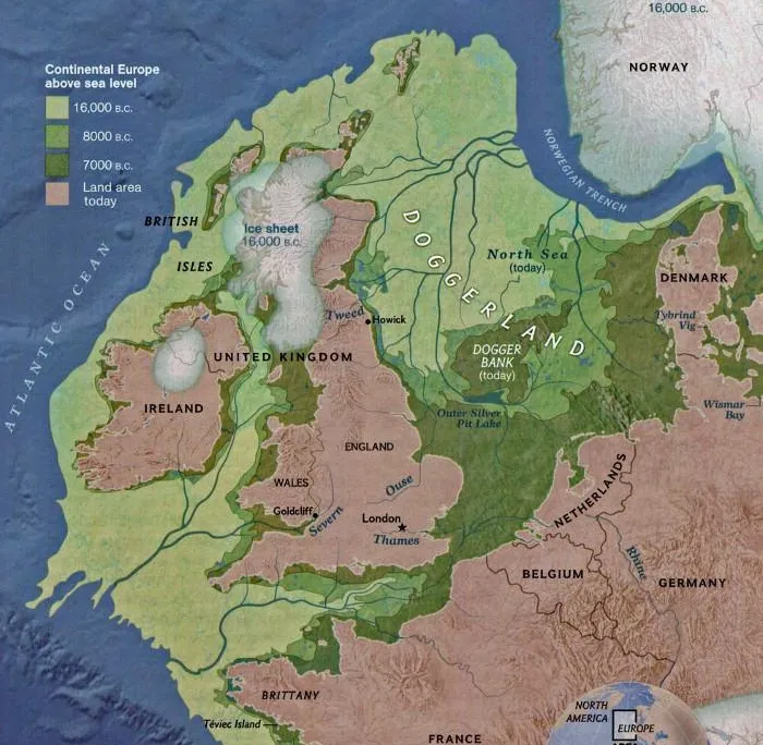
Doggerland was a plain of more than 44,000 square kilometres beneath what is now the central and southern North Sea, connecting Britain to Scandinavia and the European mainland. It was not a mere crossing point: broad river valleys, freshwater lakes, estuaries and temperate forests of oak, hazel and elm supported deer, wild boar, aurochs and migratory birds in remarkable numbers.
"There were forest resources — deer, wild boar, and berries — but also fish, migrating birds, otters, and beavers. It was a Garden of Eden for them."
— Luc Amkreutz, National Museum of Antiquities, Leiden
During the Mesolithic it was likely the most densely populated landscape in north-western Europe. Its people fished its rivers, hunted its forests, and buried their dead on ground that now lies twenty metres and more below the waves.
The Submergence
Doggerland did not vanish in a night. It drowned over four thousand years, generation by generation; its people were among the first in human history to lose their world to a changing climate.
As the last glaciation ends, hunter-gatherers move onto a vast plain of tundra becoming forest, threaded with rivers and lakes, stretching from Yorkshire to Jutland.
Meltwater lifts global sea levels by roughly six feet a century at the peak. Coastlines retreat within single lifetimes; the plain thins into marsh, then into an archipelago.
A submarine landslide off the Norwegian coast sends a tsunami across what remains of the lowlands. For the communities on the low islands there was no high ground.
The last island slips under. Its summit survives as the Dogger Bank, and the North Sea takes its modern shape; the world beneath it goes quiet for eight thousand years.
The Seabed Today
Yes: not as legend but as seabed. The plain survives beneath the North Sea, its river valleys, lake beds and coastlines preserved under metres of marine sediment. Its highest ground is the Dogger Bank, a great sandbank lying 20 to 30 metres below the surface and named for the Dutch fishing vessels, doggers, that worked it for centuries. When the waters closed over the region, it was the last island standing.
The sea keeps returning pieces of the old world. In 1931 the trawler Colinda hauled up a barbed antler point from 36 metres down off the Norfolk coast: the first human artefact recovered from the North Sea, with pollen in its surface proving it had been lost in fresh water. We tell that story in full in The Colinda Point. Since then, nearly two thousand barbed points have surfaced in nets and dredgers, alongside mammoth bone, worked flint, and the lumps of drowned peat the old fishermen called moorlog.
The Science
The name is younger than the science suggests: archaeologist Bryony Coles coined "Doggerland" only in 1998, and the two decades since have turned speculation into cartography.
Vincent Gaffney's team at the University of Bradford, working with three-dimensional seismic survey data obtained from the petroleum industry, has mapped tens of thousands of square kilometres of buried rivers, lakes and estuaries. Sediment cores now yield environmental DNA; one study identified 574 plant species from the mud alone. In 2019 the team retrieved a worked flint from a submerged river estuary, the first artefact deliberately prospected from the open North Sea seabed rather than trawled up by accident.
The work continues under SUBNORDICA, a €13 million European research programme; its stated ambition is to find not just the animals and the plants but the people, and the settlements they left on the drowned plain.
The Return
Not by itself. The seas that took it are still rising; no retreat of the water will uncover the plain again. If Doggerland is to have a future as well as a past, the land will have to be built.
That is the project this site describes. Nieuw Doggerland plans new islands on the drowned plain south of the Dogger Bank: raised by the same dredging fleets that build ports and energy islands today, sited clear of every protected sandbank, and carrying an archaeological sanctuary above the richest excavation zones. Every seabed survey that precedes a foundation doubles as archaeological prospection, at a scale the discipline could never fund alone.
The people of Doggerland were among the first to lose their world to rising water. Eight thousand years later, on the same ground, the answer to a rising sea is no longer retreat. See where the new land sits on the interactive map.

Get Involved
The heritage mission needs archaeologists, marine geophysicists and Mesolithic specialists as much as the engineering needs dredgers. If the drowned landscape is your field, there is a place for you in the Founding Circle.
Get Involved